By early this morning radar observations showed that Tracy had changed direction and was moving south. During last night the winds started to strengthen at Cape Fourcroy on Bathurst Island and by 9 am had then backed from north northeast to northwest and reached wind speeds of 120 kilometres per hour. Only a few hours ago, we received Cyclone Warning No. 15, stating that severe tropical cyclone Tracy was centred only 115km away from Darwin and was moving south. At 12:30 pm today we received a FLASH CYCLONE WARNING, that confirmed that cyclone Tracy was now heading southeast, directly towards Darwin. Very destructive winds are to be expected throughout the afternoon and the estimated time for the inevitable direct impact will be 10 pm tonight.

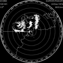
- Radar view of the incoming cyclone - (bom.gov.au)
“We only just had a cyclone warning 10 days ago, saying that it was coming, it was coming, and then it never came. So when we were just told that there was a new cyclone coming named ‘Tracy’, we were all a little blasé.“ - Darwin Resident
Warnings have been issued to as many people as possible to allow for evacuation and the safety of all residents. We should expect heavy seas, high winds, storm surges, flood rains and even landslides, so please take shelter as cyclone Tracy is more serious than first anticipated!